Maps, Maps, and More Maps
By: Lowell
Published On: 11/10/2006 9:19:54 PM

See after the "flip" for more...


Comments
am I reading this right? (TurnVirginiaBlue - 11/10/2006 9:23:07 PM)
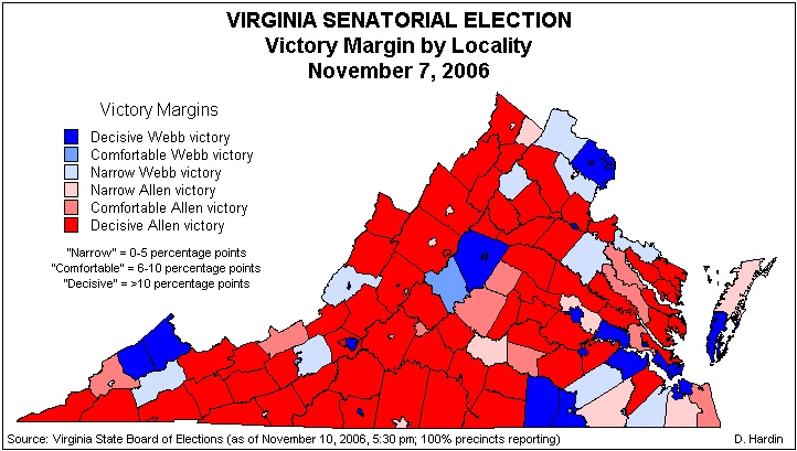
That is was Webb's "Kin" in SW VA that made the difference?
Well, since the race was so close... (Lowell - 11/10/2006 9:24:59 PM)
...I suppose you could say that. However, you could also say that if we had had better weather in NOVA, Webb's victory margin would have been a lot higher. As Don Rumsfeld might say, these are all "known unknowns." Ha. :)
Southwest Virginia... (Nick Stump - 11/10/2006 9:46:03 PM)
...should surely be commended for stepping us. There's a lot of progressives in those hill, and even more Roosevelt Democrats. If the party spends more time organizing there, given time, Southwest Virginia will indeed become Webb Country.
RE: The Kilgore factor (JPTERP - 11/10/2006 10:06:47 PM)
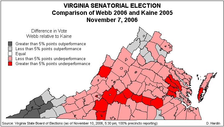
in 2005 is almost certainly part of the reason for the swing. Kilgore was from SWVA, so the "R" support was probably overrepresented in that one election. To get a measure of baseline support for the GOP in SWVA you'd probably want to look at the presidential numbers from 2004.
I hear a lot of pundits and political experts talking about the disconnect between Northern VA versus Southern VA when trying to frame the narrative in this election.
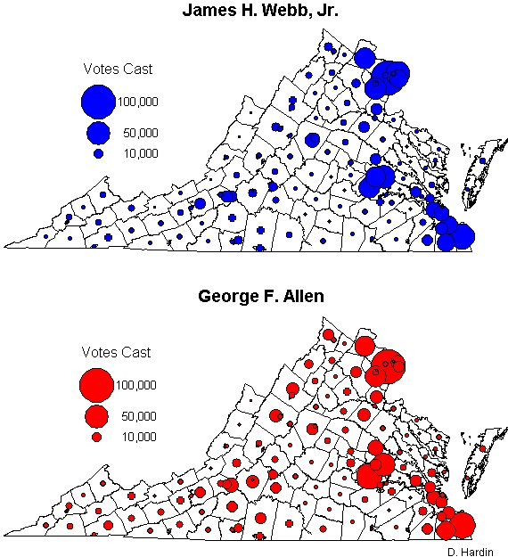
What I'm seeing though is that areas with higher population density tend to vote Democratic (e.g. Roanoke City broke for Webb, Richmond City broke just as heavily for Webb as Arlington and Alexandria, there's Norfolk, Chalottesville broke for Webb by even bigger margins than Arlington or Alexandria. Even in cities that Allen "won" such as Harrisonburg and Staunton, the margins were narrow--from anywhere from 1 to 3 percent).
If there is a split it seems to be urban versus rural. And even that generalization doesn't work 100% of the time.
I have no clue (TurnVirginiaBlue - 11/10/2006 11:37:42 PM)
How about this, a lot of Americans can recognize a stand up guy.
RE: That doesn't hurt either. (JPTERP - 11/11/2006 3:11:51 AM)
Kudos (mkfox - 11/10/2006 10:00:20 PM)
to Buchanan County (that pointy blue county bordering West Virginia and Kentucky down there) where the macaca incident happened for going Dem! Kudos also to Dickinson County and Norton for their support!
Notice how Davis... (Loudoun County Dem - 11/11/2006 5:19:25 PM)
...is trying to preemptively shove Allen out of the Senate race in 2008...
"I'm not sure you write an obituary yet," Rep. Thomas M. Davis III (R-Va.) said Thursday. "This is a loss, but he could still come back and be governor again. He got caught up in a bad year, and it was a tough campaign."
...subtext, "Don't 'F' with my plans 'neck"...
Whoever does these maps- Thank you! (thegools - 11/12/2006 12:03:32 AM)
I have been waiting to see these things. I really like them.
On the last map, does anybody have any ideas why Bath county stands out so redly, and does anyone have any idea what that Red band running through southern Virginia is?
Red band through Southern VA (tmp - 11/12/2006 10:01:53 PM)
Not sure if anybody is still reading this thread but I wonder if the red band is a result of Virgil Goode's race which wouldn't have been present in the off year election. He is very popular.
3d View of election results (tmp - 11/12/2006 12:33:03 AM)
I'm so glad to see someone making worthwhile analyticalk maps of the election results. I have a 3d (and 2d version) posted at:
www.VaElection.org
Feel free to download the pdf to see the 3d in greater detail. Great site...thanks!


